Update 58: West to Arizona Jan. 18- Feb. 1
After Naples we felt ready to head west looking for sun and warm temperatures. Since we had driven down Hwy. 41 the day before coming from Fort Meyers, we opted to forgo the traffic lights and go north on I-75 right up the peninsula. We spent one night in Alachua at a nice park called Traveler's Campground. I found it interesting that all overnight guests are lined up in rows, one right after another. Should you want to leave before the one in front of you a road separating the lines of RVs allowed you to exit. The owners here have about 20 tropical birds, mostly macaws. Some of their birds are 35 years old. That demands real commitment to a pet! They also have horses and I shot a photo of the owner exercising a horse while the man rode an ATV. We also saw our first hill in a couple of months.
We took Highway 27 east through farmland with dairy cows and sheep. We didn't expect so much farmland with animals in this part of the state. The road led through the small town of Perry. The buildings in Perry included the usual grocery store, gas station, post office and a court house. Two bail bondsmen were available on the main road. These were probably needed with the 3 correctional institutions and one work station nearby.
Next we passed through a wildlife management area that had palm, pines and cypress standing in water. The area was void of any kind of wildlife that we could see. Further on we saw land that held hunting leases for deer and turkey.
Hwy 27 joined with US 98 the road that follows the shoreline. Carrabelle was one of the many little towns that sit right on the shores of the Gulf of Mexico.
We seemed to cross a lot of bridges or causeways as we headed west along the beaches. The power poles in the water here had birds sitting on the crossbeams and on little pegs that extended at interval up each side.
Eastport looked like a typical small fishing town. I thought it would make a good movie location for an example of small town America.
Mexico Beach looked like many other Gulf beach towns. Lots of condos filled the skies. The beach side of the road had some condos and single family homes. The town was painted with a colorful array of bright paints that gave the town a south of the border feel.

We passed Okaloosa Island and begin to see the white sand beaches.

On this dreary day the white sand almost looked like snow. With the weather we have been having snow may not have been a surprise. Parts looked like Florence OR, except the dunes are white like snow.
As we drove across the bridge into Panama City the high rises filled the skyline. Someone in the Naples KOA had suggested we stay at Topsail Hill Preserve State Park. I expected it to be on the beach, and have a $22 fee. Wrong again. Topsail was 3/4 mile from Santa Rosa Beach, and it was a concessioner park at $48/night. It was a lovely park. Each site was well designed, and the whole park was very quiet.
Destin FL is an Emerald Coast destination resort. It reminded us of Myrtle Beach or Ocean City. The high rise condos pieced the sky with distinctive architecture. Any type of cuisine could be found in the many restaurants of the city. Strip malls, an outlet mall and trendy shops could keep the shop til you drop visitors busy. Miniature golf, water parks, bungee jumping, gift shops, T-shirt and swimwear shops and anything else one would desire at a destination resort. Six lanes of divided highway pass through the busy town. New construction showed up in several places.
We passed through the town of Mary Esther. How would you like to live in a town called Mary Esther?
The highway was called Air Commando Blvd. The name reflects the presence of our country's Special Operation Command forces that call Mary Esther home.

Pensacola came next. In downtown this set of pelicans decorate the street corners.
I didn't see the Navy pelican in time for a photo, but I did catch the ones for Marines, Air Force, Coast Guard, and Army.
From Pensacola it's a short trip into Alabama.We drove into Foley, which turned out to be another "big city-have everything place". The town of Gulf Shores AL lies a few minutes south of Foley. I had selected the Island Retreat RV. Again I was hoping for a beach nearby, and again I was disappointed. To reach the beach we drove over a causeway to a strip of sand. Gulf Shores took on the familar look of an East Coast beach town with high rise condos, homes on stilts, restaurants and amusement places.
We stopped at the public beach and got out to view the white sand. Of course I walked down to the water and got my feet wet. Derrille used some of the time to talk with Jay.
This sign was posted near the beach entrance. It says this beach has been impacted by the oil spill, and warns that oil may come and go. If you see it, don't enter the water. Then it lists what to do and not do if you see oil.
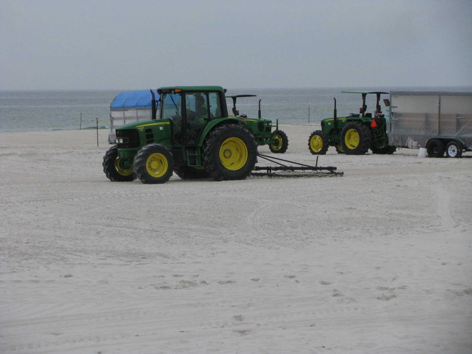
Large construction equipment also occupied part of the beach. This is an active oil spill clean-up site! Large mechanical shovels dig deep holes in the beach. Scoops of sand get dropped into a huge sieve.
The sand leaves the sieve and is recovered by dump trucks and dumped back on the beach. First a bulldozer smoothes out the pile of sand. Then a tractor pulling a screen rakes the sand smooth.
Across the road from the beach and at several places along this strip of land, large staging areas hold more equipment needed for the clean-up efforts. We found it interesting to watch the process. We drove up and down this main street to see what's here.

The condos and hotels rise up from the sand.
The pastel colors dominated these condos and homes. Here are the buildings from a street view.
Here are a couple of single family homes.
We rolled through Mobile AL via yet another bridge.
One of their attractions is the battleship Alabama.
This awesome tunnel is part of I-10 as it passes under? Mobile or the bay or something.
Then we came out in this curving road.

Alabama from Florida to Mississippi is only about 60 miles as the crow flies. But to get around Mobile Bay and hook up I-10 we drove 80 miles through Mobile and into Mississippi. The photo of the house is a state Visitor Center.

A couple of landmarks for Biloxi can be the water tower and the lighthouse.
The casinos of Biloxi surprised us. Billboards advertising current or coming acts stood at intervals before the city limits.
We didn't realize that the Hard Rock chain also had a casino, besides the restaurants.
Between the casinos were the usual condos. We even found a Catholic Church and a Art Museum along the strip.

The white flat beaches continued pass the length of town. Very few if any people were using the beach areas.

Biloxi flows into the bigger town of Gulfport. The divided road shows the vacant white sand beach on our left and vacant lots on the right.
A few older homes appear once in awhile, but many house look like new construction. It dawns on us that these miles of empty lots for sale may have been homes before the last big hurricane hit this area. The area looked like it was in a state of recovery.
On the beach we spotted another oil cleanup crew.
The town of Long Beach made us chuckle since we had observed the white sand beach the LONG way from Florida.
We decided to stay at a state park near the beach. Leaving the highway we needed to go over a steep railroad crossing. A Road Closed sign sat off to the side. The road looked patchy, but open. When we reached the beach road, the passage on the right toward the State Park looked rough and questionable, so we nixed the state park. We turned left onto a newly constructed road surrounded by an active construction zone. We didn't know where this went, and most roads we passed dead ended. Where were we going to turn the RV. So we stopped a man walking along the new sidewalk. He said this road ended in a few blocks and the cross street would take us back to a more or less main road., and sure enough it did!
As we found out way back to I-10 we passed under I-10 to access the westbound on ramp. A large sign remembers that here at Mississippi Exit 13 and I-10 was the Katrina High Water Mark in 2005. What a sobering thought that anyone under the overpass in 2005 would also be under 10-17 feet of water.
Being back on I-10 with a straight shot west to Arizona, Derrille and I considered this to be the official end of our once in a lifetime trip.
We decided to not stay in Mississippi and headed for Louisiana. We found a great park in the little town of Livingston, LA.
At the Lakeside RV we backed in next to the little lake on a paved site.
The little lake was very calming.
A black swan and a white swan make this their home. The sun was out, but it was cold. The side was so nice we decided to spend another day.
I-10 through Louisiana passes through the Atchafalaya Basin. A 19 mile bridge keeps travelers about the bayou. Fishermen could be seen from time to time in the water of the basin. As we came into Lafayette LA we saw a billboard advertising Prejeans restaurant. It felt a bit strange to know Prejeans, a place we ate in 2006.
FYI: Texas IS big. The first exit over the border is Exit 880.
After a few more exits, we stopped in Rayne, TX also known as Frog City to fill up the fuel tank. We found diesel at $3.19 even though the station across the street offered diesel for $3.37.
We continued on through Houston. The maze of freeway quickly showed we were back in a large city again.
We stopped at a Columbus KOA for the night. The park was a great overnight stop, except for the trains. RVers expect train noises because of where parks need to be located. Here however, the train felt like it was running right up against the rig. Not only that but they must pass several crossing, because the horn bellowed 4-5 times with each passing. Every picnic table in the park showed the Texas colors and trademark star of Texas.

San Antonio is considered in the hill country of Texas. The evacuation signs along the highway indicate the shoulder can be used.
Houses are built on top and into the hillsides. The shopping mall is called The Rim. We spotted Hill Country Nursery and the Blue Hills condos.


It was pleasant to be among hills again.
Near Fort Stockton we were surprised to see a couple of javelina munching alongside the highway. It took a few minutes to recognize what they were, and then we were moving on. I wished my camera had been handy then. Oh well...
Fort Stockton became the end of our day. The Fort Stockton RV had a little restaurant on site so we went in for dinner. A friendly couple we'd seen at check in was also dining. We began talking and discovered that they lived in Kingston, WA. Then we found out their children went to Esquire Hills and that Sue had worked with one of my teaching partners Sue Stine. In fact, their husbands have a consulting business together. At that time they lived up in Tremont in a cul-de-sac where I know many of their neighbors. They left Bremerton just before I arrived at Esquire Hills. We enjoyed their company that evening and again at breakfast before we both took off again.
The panhandle of Texas can be somewhat bleak, but there is a beauty in that too.
A variety of desert vegetation appears depending on the elevation of your location. This same landscape remains throughout New Mexico and into Arizona.

By choosing to go to breakfast, we had gotten up early. Thus we were on the road earlier than usual. Then we picked up an hour changing time zones....again. Hello New Mexico !
Hello Arizona! The building is the Arizona Visitor Center at a rest stop. You may also see signs warning you to stay on the path to avoid snakes.

In Eastern Arizona on I-10 the landscape on each side becomes mountains of large boulders. We've seen these between California and Arizona on I-8 and in the Joshua Tree NP area. Awesome to see!

Tucson is high desert country. Prickly pear cacti in green or purple are a common site. The Teddy Bear Cholla in the photo center also is common to the area.
The Saguaro cacti with arms that take 100 before they form are protected by the state.They can be found in yards and fields around town. Tucson is laid out in somewhat of a grid fashion with main roads being 4 lanes. Travel is fairly easy through the city, unless you find yourself in rush hour traffic.

The city sits in a high valley surrounded by mountains.The overpasses display desert themes in colored concrete. The long day's travel put us into Tucson about dinner time.

We spent the next six days in Tucson cleaning up the RV, and visiting with Lynn and Jay. We went to their neighborhood block party and met their great neighbors. Then we headed up the highway pass Picacho Peak and saguaro on our way to Phoenix.

On February 1, 2011 we arrived at the Paradise RV Resort in Sun City, AZ. It felt a bit like coming home...at least to one of our regular homes away from home. This is year 10 for Derrille to do baseball spring training.
We like our new site and are ready to sit for a couple of months in the sun.
Next: Reflections of the trip.