# 65 Emerald Isle
and Fort Macon
October 9, 2019

The landscaped changed as we moved North Carolina the Emerald Isle outer banks called the Crystal Coast.


We were parked on a terraced hillside and could see the Atlantic. This is the Holiday Travel-L Resort on Emerald Isle.


A nice boardwalk leads to the beach.


Benches provide a place to sit and watch the ocean if you don’t want to walk in the sand.


The beach looked very inviting.


The beach access had a couple of amenities. Golf carts can park right at the bottom of the entry boardwalk. A huge recycle container stands ready to accept your empty bottles. Two showers help get the sand off after time on the beach.


We took a drive up the island to check it out. We found many of these large beautiful buildings which appear to be condos for rent.


These two were villages of similar buildings.

In between the grand and glorious you can find single family dwellings.

We drove to the end of the island, as is our custom and
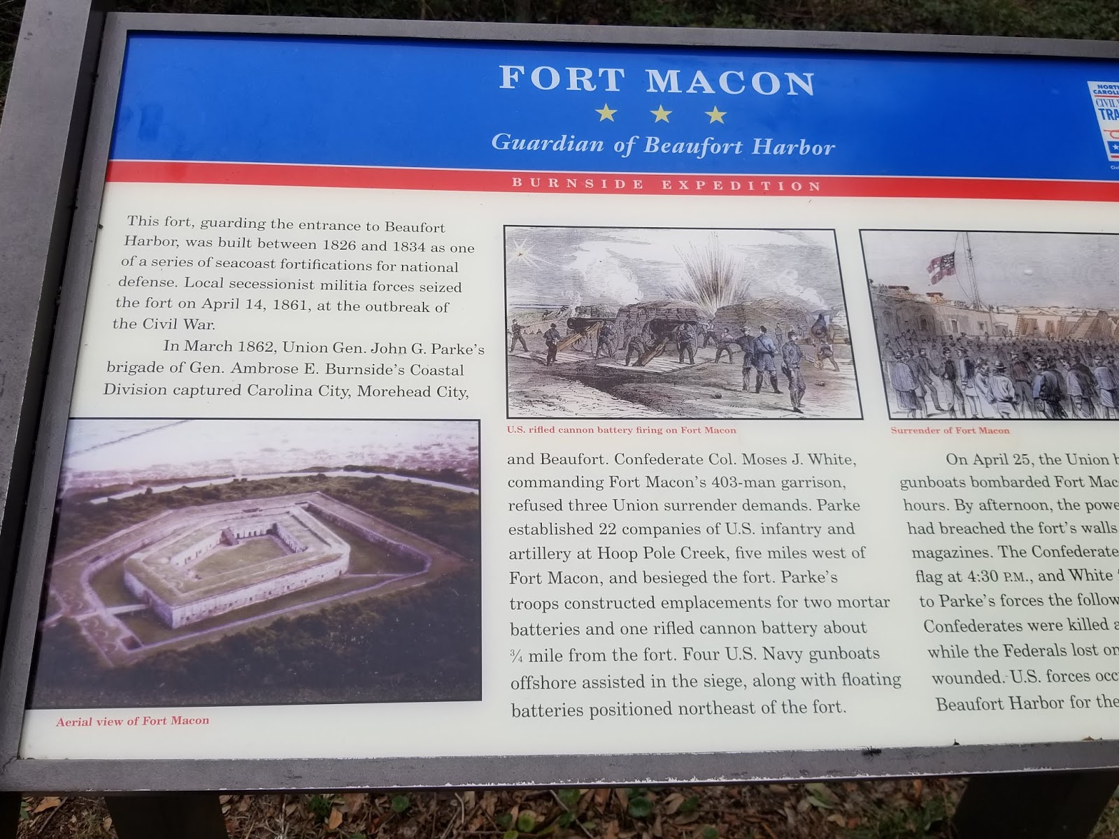
were surprised to find Fort Macon! Built
in 1826 to protect the entrance to Beaufort Harbor, it has a history of
Confederate take over and other uses over the years.


The visitor center behind this plain facade offered more surprises. Apparently Fort Dobbs and Fort Hampton preceded Macon.


Fort Macon now is part of the North Carolina State Park System. We have seen other forts with this design before.


After watching the introductory film we entered the museum. The first exhibit talks about Dr. Elliott Coues who wrote the “Key to North American Birds” while stationed here. His work made him a renowned ornithologist. They had some bird carcasses that I didn’t want to photograph.


One large section dealt with the purpose of the outer
banks.


An elegant diorama describes the four areas. The Beach accumulates loose sediment. The tides and storms over wash the beach killing or uprooting vegetation. Dunes provide a place for vegetation to take hold. Plants and animals need to deal with extreme conditions. Summer days are in the 90s but if a thermometer is put in the sand it could register 140 degrees.


Turtle nests here. Our RV rules sheet stated a warning to stay away from nests, and refill any holes kids digs in the sand.


Sea Oats adapt very well to the shifting sands and extreme temperatures.


The Maritime Forest forms behind the dunes, shaped by the wind and salt spray. The forest grows away from the ocean and salt spray forming an almost unbroken canopy that shelters other plants and some animals.


The dioramas even shows the footprints of a variety of animals. I didn’t realize that fresh water is lighter than salt water so it rises and forms done-shaped “fresh water lens” beneath the soil.


The salt marsh stands between the forest and the sound on the inner side of the island. The salt marsh provides the most productive habitat on earth and forming the base of a vast food web in the estuary.

I had never thought about the techniques birds use to catch fish: plungers, surface divers who use their feet, surface divers who use wings, skimmers and scavengers. Amazing!


A section is dedicated to our troubled waters and our need to take care of them. The kids in the last photo collected a bunch of junk of the beach at Fort Macon. I didn't get a photo of it standing there.

The plastic debate goes on!


After a visit to their quality gift shop we headed out to the fort itself.

I couldn’t resist taking this photo! Those of you who know me may be aware of my
tendency to not watch I am going and falling. I was very careful here.


Derrille and Jay are coming back to join Lynn and I as we enter the fort. The path crosses the moat area.


Some of the interior rooms were closed while drying out from Hurricane Dorian.


The interior of the fort. I found it very peaceful to be in this small grassy area this day.


This is not a barbecue! This Hot Shot Furnace heated non-explosive cannonballs to set unarmored enemy ships on fire.


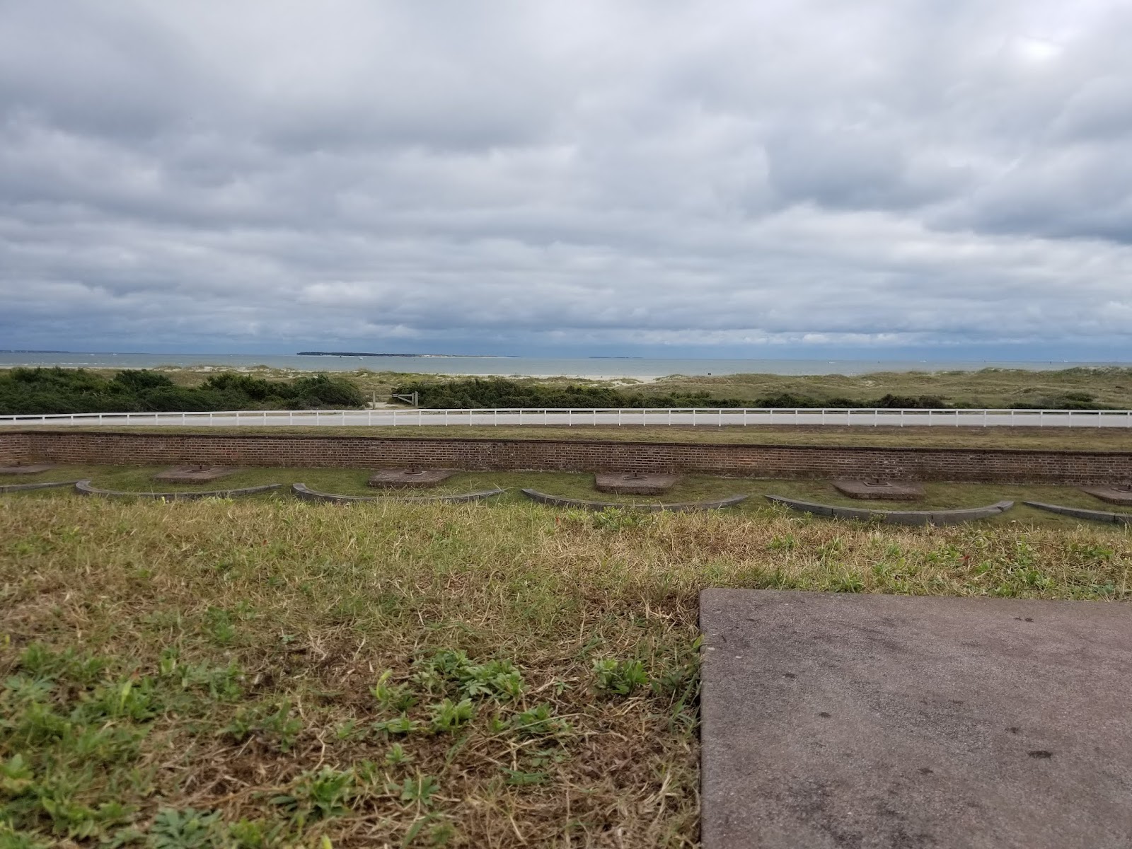
We climbed the step to the where the cannons were mounted
and facing the sea.


The fort did not sit among trees then, as it does now. From one part up here we could look down into the moat area.


Reader boards under a gazebo told how the fort has changed over the years. I enlarged these so I hope you can read them.


The officer quarters looked pretty standard to the normal quarters and homes of the time.


During WWII Fort Macon was occupied by the US Army and
the fort once again looked like a small city.


The Coast Guard station today.


Another set of reader boards told of the Bogue Banks
Lighthouse and Beacon. Bogue inlet is part of the Intracoastal waterway.
On to a trip across the bridge to Morehead SC.
On to a trip across the bridge to Morehead SC.
No comments:
Post a Comment