July 12, 2019
For you Fit Bit
wearers, we walked over 12,000 steps today!
Considering I had difficulty walking 3 feet last month, today felt like
a major feat! No pun intended!

The day started at
the Gros Morne NP Visitor’s Center on Norris Point. A park pass allows you to visit certain areas
of the park, like our destination today. The Viking Trail along the western
coast of Newfoundland and Labrador is to step back in time. The exhibits tell of colliding continents,
glaciers and the sea. The tale of the
indigent people and their travels are included.


A couple of things I
liked.

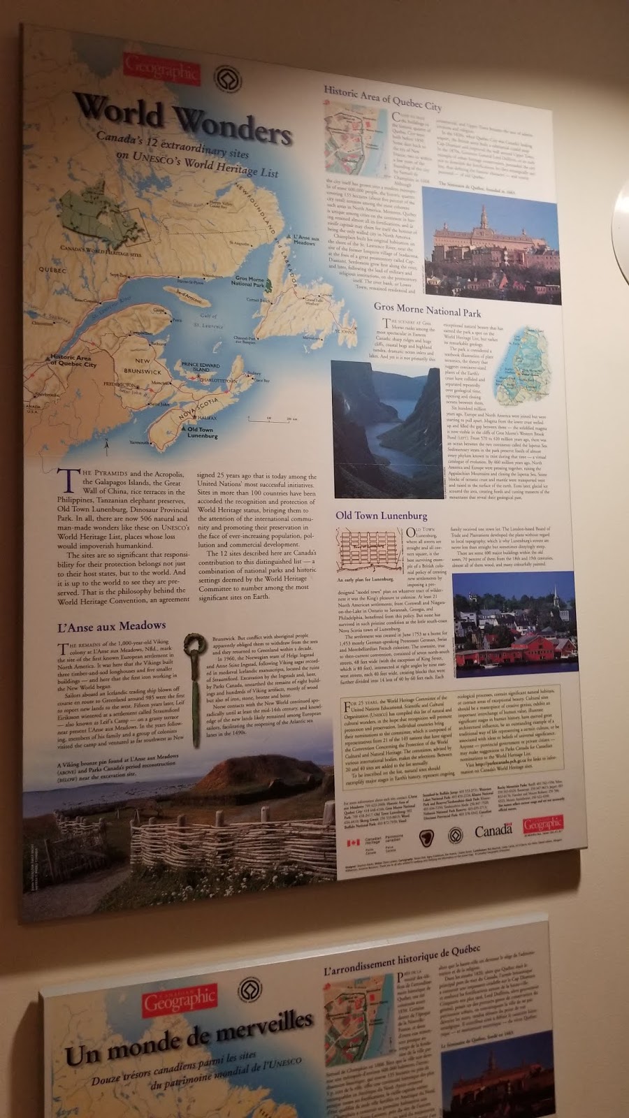
Point of interest to
us! 12 of Canada’s extraordinary sites
made the UNECSO World Heritage List. In case you are wondering what they
are: Gros Morne NP, Historic Quebec City,
Old Town Lunenburg, L’Anse aux Meadows
(we will be there next week), Head Smashed in Buffalo Jump, Waterton Lakes NP, Klune NP, Dinosaur
Provincial Park, Canadian Rocky Mountain Parks and Skung Gwaii, off the Queen Charlotte Islands,
Nahanni National Park Reserve in the Northwest Territories and Wood Buffalo NP
in NE Alberta. Except for the last three, have been to the other nine.
For all of you
shoppers, the gift shop held a treasure trove of merchandise, some of which
came home with us.


Lobster Cove Head
happened to be on the way to our destination. So we stopped.


This lighthouse was built by the government in 1898. Until then residents donated kerosene lamps to keep a light burning in the Rocky Harbor house. The out ports on the west side of the island were last to get real lighthouses. Tending the burning flame was a twenty-four hour all family job.


The clapboard house was home to several light
keepers and their families for over 100 years. To our surprise some keepers
spent 30 or 40 years of their lives tending the light.

Tide pools sit below
the lighthouse. Guides are there sometimes. I would have liked to see them,
however it was a long way down the beach trail, AND you have to come back
up. I didn’t want to jeopardize the walk
to the boat tour.

Today’s destination: Western Brook Pond boat tour.
This 10 mile body of
water does not resemble a brook or a pond.
It looks like a large lake! Unless pond is Newfie for lake! Its
maximum depth is recorded at 541 feet.
At one time it connected to the sea.
With the Ice Age and continental changes, the water became land
locked. The fjords now hang over fresh
water, some of the purest in the world. Fjords
are steep sided; U-shaped glacial valleys, that open to the sea and usually
fill with salt water. Hanging valleys could be seen from the boat.


The purity of lake
shows lack of nutrients to support life.
No river feeds this lake so no contaminants come in. The beautiful
waterfalls only display their beauty because of rain and melting snow. Only a
few species can live in the water. 450
Caribou live in Gros Morne NP. 3400
moose reside here making it the largest concentration of moose anywhere. The entire province provides homes to about
100,000 moose. Two moose were introduced
to the island in 1878 as a food source.
In 1904 another six were brought in. Today on the island about 3
moose/square mile is average. In the
park the average jumps to about 6/sq. mile. Have we seen any in the
Park????? No!


To reach the tour boats,
visitors must hike 2.4 km (1.5 miles) on this gravel path. Along the way wild iris popped up from the
bog. The ever present lily pads with
their yellow flowers float in pools of water.
The guides rate this path EASY.
However, easy includes a couple of good hills to go up and down. For Lynn and I with our undependable left
legs, the walk challenged us. I had been
prepping for this hike since last fall.
Little did I know my leg had other ideas! We allotted lots of time and strolled
out. As it turned out we made it in good
time.


The south side looks like a lake. The north side looks barren.


The pictures cannot capture the immensity of these mountains.
150925


Check out the small boat on the other side of the vegetation. It is that little white dot above the rise in the green vegetation. The mountains dwarf that tour boat that holds 84 passengers.


We were surprised to find the dock area included a ticket counter, gift shop, snack bar, outside grilling and restrooms. Notice the chipmunk. He or she begged for food. Showing no fear of humans it scoured the deck seeking food. My peanut butter sandwich was a draw and I had to say “no” several times. We have learned not to feed wildlife, because it can change their digestive tract and then they starve when they have to rely on what should be their normal diet.

A tour boat leaves
from Norris Point and we thought about signing up. You could get on most
anytime. Then we checked the Western Brook Pond and all of their Friday tours
were booked, except for the 4:00 run, so decided to take that one. Even at 4 pm the sun shone high in the sky, a
mild wind blew and the day met the requirements for beautiful.

Luckily the guys
claimed a spot near the front of the line and we were able to sit topside.
161552 161712 162214


The mountains tower over you as we motored by. The top plateau rises about 2200 feet above the water line, and then way down in the water itself. The depth of the water at the cliffs is about 350 feet.


These particular
mountains of the gorge were formed by the tectonic plates pushing them up.
The steep escarpments of the Long Range Mountains mark a fault in the Earth’s crust. 400 million years ago in Devonian time the land was thrust up and over land. During the Ice Age glaciers flowed off the plateau more than 100 times scouring the river valleys into cliff walled troughs.


More mountain shots. It was like being at the balloon fiesta and excited about each new angle.


This is one of the waterfalls.


Areas of lush greenery filled some spaces.

These bookshelf-like area had magma shoot up the columns and then retreat to earth. There is a face dubbed the Tin Man in the rock.


Another waterfall high above us.


On the south side of the gorge this water fall found a path down to the lake.


I found this the most impressive waterfall of the day.

The end of the
lake!

I am including this one with all the people so you can see the dock in the background. The dock is just off the bill of the man's hat. If you are an experienced hiker, and can pass the test at the visitor center, you are awarded a compass, a map and a pass to the back country. You also receive an emergency beacon. Then the tour boat will deliver you to this dock for you days in the wilderness. Should emergency evac be needed, helicopters are available.


I am including this one with all the people so you can see the dock in the background. The dock is just off the bill of the man's hat. If you are an experienced hiker, and can pass the test at the visitor center, you are awarded a compass, a map and a pass to the back country. You also receive an emergency beacon. Then the tour boat will deliver you to this dock for you days in the wilderness. Should emergency evac be needed, helicopters are available.


Yes those white
patches you see are really snow!


One of the cliffs
here called Broken-off Hill stand at 715 m which is 150 meters taller than the
CN Tower in Toronto.


Our 2 hour tour crew
consisted of Carter, KJ, Jamie and Captain Andy. They kept us laughing all the
way. On the way back K.J. entertained us
with his music. If you wanted you could
buy his CD. A good time was had by all.
Tomorrow Woody Point
No comments:
Post a Comment